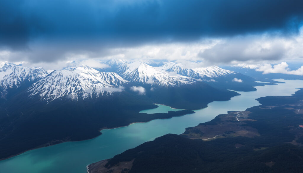
Te Waipounamu / South Island: Meaning, Geography & Highlights
Few place names carry a story the way Te Waipounamu does. That’s the Māori name for New Zealand’s South Island, and it translates to “waters of greenstone”—a phrase tied to ancient legends and the precious pounamu found in its rivers. This guide explores what that name means, where the island sits, and the places travelers keep coming back to.
Population: 1,256,000 (2023 estimate) ·
Area: 150,437 sq km ·
Highest Point: Aoraki / Mount Cook (3,724 m) ·
Largest Lake: Lake Te Anau (344 sq km) ·
Largest City: Christchurch (389,300)
Quick snapshot
- Official dual name since 2013 (Land Information New Zealand)
- Ngāi Tahu is the largest iwi in the South Island (Wikipedia)
- South Island area: 150,437 km² (Wikipedia)
- Te Wāhipounamu is a UNESCO World Heritage Site (Wikipedia)
- Exact number of full-blood Māori (no official census category)
- Whether North or South Island is “more beautiful” remains subjective
- Which specific place is “best to live” depends on personal factors
- c. 1000 AD: Polynesian settlement; name Te Waipounamu originates
- 1840s: European colonization; “South Island” becomes common
- 1998: Ngāi Tahu Treaty settlement provides economic base
- 2013: Official dual name adopted
- Growth in adventure tourism continues around Queenstown and Wānaka
- Conservation efforts expand in Fiordland and Te Wāhipounamu
- Māori cultural tourism gains prominence through Ngāi Tahu initiatives
| Fact | Value |
|---|---|
| Population | 1.26 million (2023 estimate) |
| Area | 150,437 km² |
| Highest Point | Aoraki / Mount Cook (3,724 m) |
| Largest Lake | Lake Te Anau (344 km²) |
| Largest City | Christchurch (pop. 389,300) |
| Official Name | South Island / Te Waipounamu |
Why is South Island called Te Waipounamu?
The name Te Waipounamu comes from Māori tradition and translates roughly as “the waters of greenstone” or “the place of greenstone.” Pounamu—New Zealand greenstone or jade—was highly prized by Māori for tools, weapons, and ornaments, and the South Island’s rivers were a primary source. The name reflects both the land’s resources and its spiritual significance in Māori culture.
What does Te Waipounamu mean?
- Te Waipounamu is commonly translated as “the waters of pounamu” (Wikipedia)
- Some sources note an older evolution from Te Wāhi Pounamu, meaning “the place of pounamu” (Wikipedia)
- The name is closely associated with Ngāi Tahu, the primary iwi of the South Island (Wikipedia)
The legend behind the name involves the greenstone itself. According to Māori tradition, pounamu was created from the tears of a woman whose children were turned to stone, or from the great fish of Māui. The South Island’s rivers carried this precious stone to the sea, making the land synonymous with its most valued treasure.
How do you pronounce Te Waipounamu?
Te Waipounamu is pronounced “teh why-poh-NAH-moo.” The “wh” in Māori is typically pronounced as an “f” sound in many dialects, so you might hear “Te Fai-poh-NAH-moo.” The stress falls on the second-to-last syllable of the final word.
The official recognition of this name came in 2013. The New Zealand Geographic Board formalized the dual name South Island / Te Waipounamu, alongside Te Ika-a-Māui for the North Island, acknowledging the Māori name’s cultural authority (Land Information New Zealand).
The name isn’t just a label—it’s a claim to cultural identity. For Ngāi Tahu, Te Waipounamu anchors their connection to the land and its resources, and the official recognition in 2013 gave that connection legal and geographic standing.
Where is Te Waipounamu located?
The South Island sits at the bottom of New Zealand, separated from the North Island by the Cook Strait. It’s the larger of the two main islands by surface area—roughly 150,437 square kilometers—but the North Island holds more people (Wikipedia). The island’s geography is defined by the Southern Alps running down its western spine, with the Canterbury Plains to the east and dramatic fiords in the southwest.
What are the 7 regions of the South Island?
| Region | Character | Key Centers |
|---|---|---|
| Tasman | Coastal, sunny, national parks | Motueka, Richmond |
| Nelson | Warm climate, arts, vineyards | Nelson city |
| Marlborough | Wine region, sounds | Blenheim, Picton |
| West Coast | Rainforest, glaciers, rugged | Greymouth, Hokitika, Franz Josef |
| Canterbury | Plains, alpine access | Christchurch, Timaru |
| Otago | Heritage, lakes, wildlife | Dunedin, Queenstown, Wānaka |
| Southland | Fiordland, rural, wild coast | Invercargill, Gore |
Marlborough is often grouped as a wine region and gateway to the Marlborough Sounds (Finding Alexx). Nelson pairs with Abel Tasman and Golden Bay as a warm-weather, outdoor-oriented stop (Finding the Universe). Christchurch and Banks Peninsula work as a gateway combining urban access with coastal excursions (Finding Alexx).
The seven regions span vastly different climates—from the sunny, dry Marlborough vineyards to the rain-soaked West Coast rainforests. Travelers often underestimate the driving distances between them.
The pattern: each region functions almost like a separate destination. The South Island isn’t a single stop—it’s a collection of distinct environments that reward slow travel.
What should I not miss on the south island of New Zealand?
If you’re planning a trip, the South Island delivers on dramatic scenery and outdoor adventure. The standout experiences cluster around national parks, alpine peaks, and coastal wildlife. Here’s what keeps showing up in travel guides and local recommendations:
- Fiordland National Park and Milford Sound—fiords, waterfalls, and Great Walks (New Zealand Sky)
- Aoraki / Mount Cook—premier alpine hiking and high-mountain scenery (Finding the Universe)
- Queenstown—adventure sports and lakeside base (My Queenstown Diary)
- Abel Tasman National Park—coastal kayaking and golden beaches (Finding Alexx)
- Kaikōura—whale watching and crayfish (Finding the Universe)
What are the top outdoor activities?
The South Island’s landscape sets up adventure travel naturally. Queenstown and Wānaka are the major bases for bungee jumping, skydiving, jet boating, and skiing (Finding the Universe). The Great Walks—including the Milford, Routeburn, and Abel Tasman tracks—draw hikers from around the world. Fiordland offers multi-day treks through rainforest and alpine terrain (New Zealand Sky).
For wildlife, Dunedin and the Otago Peninsula deliver albatross colonies, penguins, and seals (My Queenstown Diary). The Catlins offer a quieter, less-developed coastal alternative (My Queenstown Diary). Stewart Island/Rakiura extends itineraries further south as a wilderness extension (Finding Alexx).
You can’t see everything in one trip. The South Island rewards focus: pick either the alpine north (Nelson, Marlborough, Aoraki) or the fiordland south (Queenstown, Fiordland, Dunedin), and save the rest for a return visit.
Why this matters: the island’s scale works against rushed itineraries. Driving between Fiordland and Marlborough takes a full day, so planning around a region rather than the whole island produces a better trip.
What is the largest iwi in the South Island?
Ngāi Tahu is the largest iwi in the South Island, with a tribal area covering most of the island’s eastern and southern regions. The iwi’s name appears throughout the Te Waipounamu place-name tradition (Wikipedia). Ngāi Tahu is also among the wealthiest iwi in New Zealand, thanks to Treaty of Waitangi settlements and commercial investments.
Are there more Maoris on North or South Island?
The majority of Māori live in the North Island. The South Island’s Māori population is smaller in absolute numbers, though the proportion varies by region. Census data doesn’t track “full-blood” Māori as a category, so estimates of pure descent are speculative.
Who is the richest Māori tribe in New Zealand?
Ngāi Tahu is frequently cited as one of the wealthiest iwi due to its 1998 Treaty settlement, which provided an economic base for investment (Wikipedia). The settlement included cash and land, which the iwi has leveraged into tourism, property, and fisheries holdings.
Wealth and population don’t align neatly. Ngāi Tahu’s economic strength comes from settlement assets, not numbers—the iwi’s membership is spread across New Zealand, not concentrated in the South Island.
The implication: Ngāi Tahu’s influence on the South Island extends beyond traditional tribal governance. The iwi is a major economic player in tourism, conservation, and regional development.
Which is more beautiful, North or South Island, NZ?
“More beautiful” depends on what you’re after. The South Island earns its reputation for dramatic alpine scenery: fiords, glaciers, and the Southern Alps. The North Island counters with volcanic peaks, geothermal areas, and subtropical beaches. Most travelers, when pressed, give the scenic edge to the South (Wikipedia).
What are the main differences between North and South Island?
| Aspect | South Island | North Island |
|---|---|---|
| Landscape | Mountains, fiords, glaciers | Volcanoes, hot springs, beaches |
| Population | ~1.26 million | ~4 million |
| Major Cities | Christchurch, Dunedin | Auckland, Wellington |
| Climate | Cooler, wetter west | Warmer, subtropical north |
| Māori Population | Smaller proportion | Larger proportion |
| Main Draw | Adventure, scenery | Culture, beaches, geothermal |
The North Island holds roughly four times the population of the South Island (Wikipedia). For visitors, the South Island delivers wilderness at scale; the North Island offers more urban energy and volcanic drama.
For travelers, the choice often comes down to priorities: the South for epic landscapes, the North for cultural depth and warmer weather.
What is the best place to live on the South Island of New Zealand?
The “best” place to live depends on your priorities—lifestyle, work, education, or community. Several spots stand out for different reasons:
- Queenstown and Wānaka—popular for lifestyle, adventure, and scenery (Finding the Universe)
- Christchurch—urban amenities, rebuilding economy, coastal access (Finding Alexx)
- Dunedin—education, heritage, wildlife, lower cost (My Queenstown Diary)
- Nelson—sunny climate, arts community, outdoor access (Finding the Universe)
Where do the wealthy live in New Zealand?
Wealthy New Zealanders cluster in Queenstown and Wānaka for lifestyle, and in Auckland on the North Island for business (Wikipedia). Queenstown’s property prices reflect its desirability.
Is it cheaper to live in NZ or Australia?
Cost of living varies by city and lifestyle. Generally, New Zealand’s cost of living is comparable to Australia’s, though housing in South Island cities like Christchurch and Dunedin is more affordable than Sydney or Melbourne. The trade-off: lower wages and fewer job opportunities in some sectors.
For families, Dunedin offers affordability and education. For remote workers, Queenstown delivers lifestyle. For urban professionals, Christchurch provides the best balance of city amenities and outdoor access.
For anyone considering a move, the South Island’s smaller cities mean easier access to nature but fewer corporate opportunities. The decision comes down to what you’re optimizing for—and whether you can bring your work with you.
Related reading: Westland Fiordland Heavy Rain: Orange Warnings and Climate Facts · Nelson Things to Do: Free & Budget-Friendly Picks
dictionary.com, zh.wikipedia.org, en.wikipedia.org, sameeroza.com
Frequently asked questions
How do you pronounce Te Waipounamu?
It’s pronounced “teh why-poh-NAH-moo.” The “wh” is often pronounced as an “f” in many Māori dialects, giving “teh fai-poh-NAH-moo.” Stress falls on the second-to-last syllable of the final word.
What are the 7 regions of the South Island?
The seven regions are Tasman, Nelson, Marlborough, West Coast, Canterbury, Otago, and Southland. Each has distinct geography and character, from Marlborough’s vineyards to the West Coast’s rainforests.
What is the flag of Te Waipounamu?
The South Island does not have an official flag. Some local groups have proposed designs, but no flag has official recognition. The New Zealand national flag remains the official flag throughout the country.
What is the population of the South Island?
The population is approximately 1.26 million as of the 2023 estimate. Christchurch is the largest city, with about 389,300 residents.
What is the history of Te Waipounamu?
Māori settled the South Island around 1000 AD. European colonization began in the 1840s. The name Te Waipounamu was officially recognized alongside “South Island” in 2013, acknowledging the Māori heritage of the land.
What is Te Wahipounamu (UNESCO site)?
Te Wāhipounamu is a UNESCO World Heritage Site in the southwest of the South Island. It covers Fiordland, Aoraki/Mount Cook, and other protected areas, recognized for its outstanding alpine, fiord, and glacier landscapes (Wikipedia).
For those planning a trip, the name Te Waipounamu is more than a piece of trivia—it’s a lens into how Māori understand this land. For Ngāi Tahu, the choice is clear: honor the name, respect the history, and let the greenstone waters keep their story alive.
More related posts
 Inter Milan vs Arsenal FC Lineups Today
 Online Casino Sites NZ: Real Money Guide for New Zealand Players
 Maxi-Cosi Car Seats: i-Size vs ISOFIX 2026 Legal Facts
 New Zealand Weather Warnings: Current Alerts & Meaning
 Good Friday Shops Open: 2026 Easter Hours UK & Ireland
 Under Armour Compression Shirt vs Nike: Which is Better
 Cast of Tinā 2024: Actors, True Story, and Where to Watch
 Houses for Sale West Auckland: Prices, Suburbs & Tips
