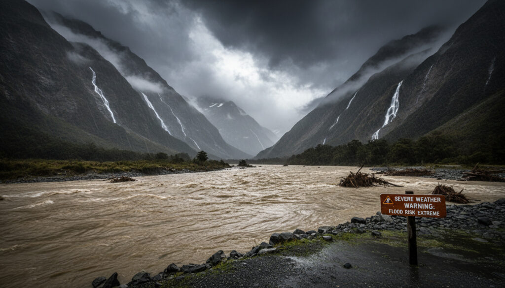
South Island New Zealand Heavy Rain – April 2024 Warnings and Risks
In April 2024, a persistent northwesterly weather system delivered prolonged heavy rainfall to New Zealand’s South Island, prompting MetService to issue multiple warnings for Westland, Fiordland, and surrounding districts. Forecasters projected exceptionally high precipitation totals—up to 800 millimetres in alpine ranges—amid concerns for rapidly rising rivers, surface flooding, and hazardous travel conditions.
The event spanned April 8 through 11, with the heaviest concentrations anticipated south of Hokitika. Strong wind watches accompanied the rain warnings, creating compound hazards across western and southern regions.
Geographic Distribution of April 2024 Warnings
Active warnings April 9–11, 2024
Westland, Fiordland, Southland
Heavy Rain Warnings and Watches
Prolonged rainfall over 72-hour window
- Westland and Fiordland faced second Heavy Rain Warnings of 2024, effective Tuesday through Thursday according to Chris Lynch Media
- Southland, including Stewart Island, operated under a Heavy Rain Watch from Monday afternoon, April 8
- Canterbury High Country, Plains, Otago, and Southland held active Strong Wind Watches with gusts reaching 100 km/h
- Forecasts predicted 600–800 mm in southern Westland ranges and 100 mm near coasts
- Heaviest precipitation concentrated south of Hokitika, feeding into Otago lakes and eastern Canterbury river systems
- Rivers and streams were expected to rise rapidly, particularly on the west coast
- Surface flooding, slips, and hazardous driving conditions represented primary secondary risks
| Region | Rainfall (mm) | Status | Risk Level |
|---|---|---|---|
| Westland Ranges | 600–800 | Heavy Rain Warning | High |
| Westland Coast | 200 | Heavy Rain Warning | Moderate |
| Southern Coast (south of Hokitika) | 200–300 | Heavy Rain Warning | Moderate |
| Fiordland (north of George Sound) | 600–800 | Heavy Rain Warning | High |
| Southland (including Stewart Island) | Watch levels | Heavy Rain Watch | Moderate |
| Canterbury High Country | Wind-focused | Strong Wind Watch | Moderate |
| Otago | Headwater feeds | Strong Wind Watch | Moderate |
Meteorological Forecasts and Projections
Northwest Weather Pattern and Timing
A northwesterly airflow transported warm, moist air masses across the western South Island, establishing conditions for prolonged orographic rainfall. The system generated sustained precipitation from April 9 through 11, with preliminary watches commencing April 8 for southern districts.
Precipitation and Wind Projections
Forecasts detailed in MetService briefings indicated rainfall totals of 600–800 mm across the Southern Alps and southern Westland ranges, with 200–300 mm projected for coastal areas south of Hokitika. Convergent wind patterns threatened gusts up to 100 km/h across Canterbury, Otago, and Southland, with temperatures in some zones reaching 30°C.
Southern Westland ranges and Fiordland north of George Sound faced the highest precipitation burden, with 600–800 mm forecast over several days—figures significantly exceeding coastal projections of 200–300 mm south of Hokitika.
Infrastructure Risks and Safety Advisories
River Level Concerns
Hydrological assessments indicated rapid rises in western rivers and streams, with headwater rainfall feeding into Otago and Canterbury river systems. Eastern basin areas faced indirect impacts as alpine precipitation moved through catchments.
Surface Conditions and Travel Risks
Authorities anticipated surface flooding, land slips, and degraded road surfaces. Strong winds compound hazards along western coasts. Emergency protocols suggest residents verify financial accessibility during severe weather periods, including banking details such as the BNZ Swift Code NZ – Official BKNZNZ22 Guide for Transfers for urgent transactions.
Position Within 2024 Severe Weather Patterns
The Near Red Warning Event
MetService 2024 retrospective analyses identified the April 8–11 system as nearly triggering a third Red Warning for the year. This followed an actual West Coast Red Warning issued April 18, which delivered 400–650 mm over 48 hours to Westland ranges, elevating rivers to alert levels and generating Canterbury impacts.
The April 18 Red Warning established a severity benchmark with 400–650 mm over 48 hours in Westland ranges, causing river rises to alert levels and affecting Canterbury—illustrating the escalation criteria that the April 8–11 event approached but did not formally meet.
Distinction from July Systems
Subsequent July 29 warnings targeted Dunedin, North Otago, Clutha, and Tasman with orange-level Heavy Rain Warnings, representing a distinct meteorological configuration with southeastern focus rather than the northwestern pattern observed in April. Sporting fixtures and outdoor events, including the Western United vs Auckland FC – Preview and Key Insights, frequently face operational adjustments during such severe weather periods.
Heavy rain warnings issued on July 29 for Dunedin and North Otago constituted a distinct system from the April northwesterly event, utilizing different warning levels and regional focuses; sources specify no direct continuity between these weather episodes.
Chronological Progression of Warning Issuances
- : MetService issued a Heavy Rain Watch for Southland, including Stewart Island, marking the initial alert phase.
- : Heavy Rain Warnings took effect for Westland and Fiordland as the northwesterly system intensified.
- : Peak rainfall period delivered 600–800 mm to southern ranges and 200–300 mm to targeted coastal zones.
- : Warning periods expired, though residual river level monitoring continued through subsequent days.
- : Separate West Coast Red Warning triggered by distinct 400–650 mm rainfall event.
- : Unrelated orange-level warnings issued for southeastern districts including Dunedin and North Otago.
Verified Details and Information Gaps
| Established Information | Uncertain or Unconfirmed Details |
|---|---|
| Warnings issued April 8–11 for Westland, Fiordland, Southland | Specific lists of road closures implemented |
| Forecasted rainfall: 600–800 mm (ranges), 200–300 mm (coasts) | Actual measured precipitation totals versus forecasts |
| Strong Wind Watches for Canterbury, Otago, Southland (100 km/h gusts) | Comprehensive damage assessments or insurance claims |
| Risks identified: surface flooding, slips, hazardous driving | Evacuation orders or emergency shelter activations |
| Meteorologist Clare O’Connor cited below-average annual rainfall prior to event | Long-term infrastructure degradation from repeated 2024 events |
Atmospheric Conditions Driving the Event
The April 2024 episode originated from persistent northwesterly airflow carrying moisture-laden air from Tasman Sea sources against Southern Alps topography. This orographic lift mechanism generated prolonged precipitation concentrated on western slopes. Current MetService outlooks indicate such patterns generate recurrent west South Island precipitation, though 2024-specific data requires archival verification.
Clare O’Connor noted that affected western regions operated below annual rainfall totals prior to this event, a factor potentially exacerbating surface saturation and runoff coefficients once heavy precipitation commenced. Temperature anomalies pushed some interior areas toward 30°C, creating unusual thermal contrasts against the precipitation zones.
Official Statements and Expert Commentary
Western regions were below annual rainfall totals, heightening risks for surface flooding, slips, and driving hazards.
Clare O’Connor, MetService Meteorologist, via Chris Lynch Media
The April [8–11] system came close to triggering a third Red Warning for 2024, following the West Coast Red Warning on April 18 that produced 400–650 mm over 48 hours in Westland ranges.
MetService 2024 Severe Weather Recap
Ongoing Monitoring Recommendations
Residents and travelers across the South Island should consult MetService severe weather outlooks for real-time warning statuses regarding heavy rain and wind events. Historical data from April 2024 demonstrates the rapid development of river rise hazards and surface degradation during northwesterly storm systems, underscoring the necessity of proactive monitoring during similar meteorological setups. Residents and travelers across the South Island should consult MetService severe weather outlooks for real-time warning statuses regarding heavy rain and wind events, and you can find a charging station near me Ireland here. charging station near me Ireland
Frequently Asked Questions
Which regions received the highest rainfall totals in April 2024?
Southern Westland ranges and Fiordland north of George Sound recorded forecasted peaks of 600–800 mm, significantly exceeding coastal areas which anticipated 200–300 mm.
Did the April 2024 heavy rain trigger civil defence evacuations?
Available sources specify no explicit reports of widespread evacuations or emergency shelter activations during the April 8–11 event, though authorities advised preparation for surface flooding and slips.
What differentiates a Heavy Rain Warning from a Heavy Rain Watch?
Warnings indicate imminent severe conditions requiring immediate action, while watches signal potential developments requiring monitoring. Westland and Fiordland received warnings; Southland received a watch.
Were strong winds concurrent with the April 2024 rain warnings?
Yes. Strong Wind Watches covered Canterbury High Country, Plains, Otago, and Southland with predicted gusts up to 100 km/h, compounding hazards from saturated ground conditions.
How did the April 8–11 event compare to the April 18, 2024 storm?
The April 18 event triggered an official Red Warning with 400–650 mm over 48 hours, while the April 8–11 system approached but did not meet Red Warning thresholds despite higher total forecasts in some ranges.
What caused the prolonged rainfall pattern in April 2024?
A northwesterly weather system transported warm, moist air across the western South Island, generating orographic lift against the Southern Alps and sustained precipitation from April 9 through 11.
Did July 2024 warnings relate to the April events?
No. July 29 warnings for Dunedin and North Otago constituted a separate meteorological system with distinct warning levels and regional focuses, unrelated to the April northwesterly pattern.
More related posts
 The Book of Mormon: Sacred Text & Broadway Musical
 How to Reduce Cholesterol: Diet and Lifestyle Tips
 In Search of Lost Time: A Practical Guide for New Readers
 Those Who Wish Me Dead: Plot, Cast, Reviews & Where to Watch
 True Value Cars Christchurch: Affordable Used Cars & Reviews
 Cast of The Family Next Door (2025) – Full List & Characters
 Australia Working Holiday Visa: Requirements & How to Apply
 Cavius Smoke Alarm NZ: Beeping Fixes & Buying Guide
